Geography
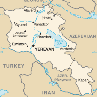
The Republic of Armenia lies in a triangular section of the Transcaucasus, bordered by Azerbaijan, Iran, Turkey and the Republic of Georgia. With an area of 29,800 square kilometres, the landlocked country is just about the size of Vancouver Island.
The capital city, Yerevan, lies on the Hrazdan River, and is home to some 1.2 million people. The next three largest cities are Gyumri (pop. 121,000), Vanadzor (pop. 74,000) and Abovian (pop. 54,000). Another important city is Echmiadzin, located some 20 miles west of Yerevan, which is the seat of the patriarchate of the Armenian Apostolic Church.
The greatest part of Armenia is mountainous (about 300 feet above sea level), while one-third is pastureland. Forest and woodland cover 12 percent of the country, arid land some 18 percent, and permanent crops cover 3 percent. The highest elevation is 4,095 meters (Mt. Aragats) and the lowest point is 400 meters above the sea level (Debed river).
There are more than 200 streams and rivers in Armenia, none navigable, however, because of their steep descents and rapid currents. The Armenian countryside also boasts some 100 small, but picturesque lakes. One of the largest mountain lakes in the world, Lake Sevan, covers an area of 1,400 square kilometres and is about 650 feet above sea level.
Climate in Armenia is continental, with lower temperatures and more precipitation in higher elevations. In central plateau temperature varies widely with cold winters and hot summers.
Source: the Web-site of the Armenian Embassy in Canada